It's taken a year to get around to writing this account of our trip to Trolltunga, but I've finally decided to put pen to paper, or should I say fingers to keyboard? Our hike to the iconic landmark, sticking out over lake Ringedalsvatnet, took place during a road trip with my two children in August 2017. My 22yr old son, Sean, had just graduated from university with an honours degree in engineering and my 19yr old daughter, Emma, was due to start her first year at university. Consequently, this would probably be our last extended trip together for a long time, if ever. For that reason we intended to cram as many really memorable moments into the trip as possible, with Trolltunga being top of the list. I have always had an affinity with Norway since first visiting Oslo at the tender age of 6 with my father and grandfather. I didn't get to return until my early thirties, after meeting the love of my life in my home country of Wales. She just happened to be Norwegian! Go figure. From then on I was a regular visitor, travelling extensively by car, motorbike, kayak, ski and foot. My kids accompanied me on many of these trips so they too were very familiar with the country.
Our planned itinerary for the next day had been to start off for Trolltunga mid afternoon, reach the top, erect our tents and make an early start the following morning to catch the sunrise. As we settled down for dinner that evening though, the sky clouded over and pretty soon there was a torrential downpour of rain.
 |
| Hildal campsite |
The rain fell steadily overnight and continued the following morning so, after breakfast, we had a family discussion as to our proposed plans. The whole idea of the walk to Trolltunga had been to enjoy the experience, something we did not foresee happening if walking through heavy rain with backpacks full of all the kit needed for an overnight stay. The walk up is estimated at 5hrs, not a light undertaking in itself, and none of us relished the idea of arriving at the top tired and wet through. Taking all things into consideration, we unanimously decided to delay our trip by a day and explore the surrounding area instead, booking ourselves into one of the cabins at the campsite for that night so that we could leave our gear behind and let our wet kit dry out.
Steinsdalsfossen is a waterfall about one and a half hours drive from Odda and is unusual because a pathway exists behind the waterfall, allowing you to gaze outwards through the cascading water, so we decided to make that our goal for the day and set off to pay a visit.
 |
| Steinsdalsfossen with the walkway behind |
 |
| Looking outwards from the walkway behind the waterfall |
After returning from our visit to the waterfall we took the time to have a better look around the town of Odda before heading back to the campsite and preparing for the following day. The weather, although still overcast, had become a lot drier and the prospects for some sunshine the following day were promising.
So, how to get from Odda to the start of the walk up to Trolltunga? Although there is a shuttle service from Odda to the start of the walk, at a cost of 180kr per person, we decided to drive to the car park where a days parking would cost us 500kr, meaning it would be slightly cheaper and allow us to do it in our own time. We could also sort our kit from the car when we got there and in our own sweet time. Details for the shuttle service, which makes several stops along the way, can be obtained from the tourist information office. There is also an overflow carpark in Tyssedal for when the higher car park is full. A days parking here costs 300NOK and a shuttle service is provided from there to Skjeggedal.
We arrived at the car park above Tyssedal at Skjeggedal and paid for our parking ticket. Of note is the fact that there is another carpark further up the mountain in which you can park for an extra 200kr, so 500kr in total. Parking there would also save you a 4km uphill walk, but we personally felt this would have been a bit of a cheat. Adjacent to the car park is
Trolltunga Active, a business which, amongst other activities, provides guided walks up to Trolltunga. If you are in any doubt whatsoever as to you ability to make the trip alone, or even if you have decided you would like some company and information from a knowledgeable guide along the way, you may well want to pay them a visit and book onto one of their guided walks. At the time of writing, the cost for the guided walks is 1100kr. The car park is huge, providing a view of the Ringedals dam and being occupied by numerous ducks who, proudly showing off their latest brood of young chicks, trotted about to the delight of the various tourists preparing to set out on their Trolltunga hike. Now, going back to the choice of car parks, in between the upper and lower car parks is an interminable stretch of tarmacked road measuring over 4km in length. It's steep, no, let me rephrase that, it's STEEP, and constantly turns back on itself. If you do park at the higher car park you miss out on this grueling section, but certainly don't miss anything in terms of views.
 |
| The car park ducks |
 |
| A novel use for old boots |
 |
| Just look at all those zig zags between the upper and lower car parks! |
 |
|
Kit? I might be teaching some to suck eggs here, but it's a really important issue. I live in the foothills of Snowdonia
, a mountain range in my home country of Wales. As mountains go they are not particularly high, but they do suffer very changeable and inclement weather. Every year our Mountain Rescue Teams are pushed to their limits attending casualties who have become casualties purely because they are ill equipped and unprepared. Snowdon
, our highest peak, is the worst example. 600,000 people summit Snowdon
every year, that's an average of nearly 1,700 people per day. It is one of the worlds most accessible mountain summits, there is even a train running up it. Because of this, it is considered more of a tourist attraction than a dangerous mountain summit, so people have become very complacent about the dangers. I have been up to the summit using ice axe and crampons, bemused at passing people inadequately dressed and wearing wellington boots. Sadly, many of the iconic Norwegian landmarks such as Trolltunga, Preikestolen, Besseggen Ridge, etc., are going the same way. For that reason, I can point you in no better direction than the NorwegianMountain Code;
1. Plan you trip and inform others about the route you have selected
2. Adapt the planned route according to ability and conditions.
3. Pay attention to the weather and, if relevant, avalanche warnings.
4. Be prepared for bad weather, even on short trips.
5. Take the necessary equipment so you can help yourself and others.
6. Choose safe routes, recognising unsafe terrain.
7. Take a map and compass. Always know where you are.
8. Don't be ashamed to turn around.
9. Conserve your energy and seek shelter if necessary.
As part of your preparation, please feel free to check out our uploaded GPS route for the trip we took, you can find that
here. It was recorded using Wikiloc, a free to download app/android, to which you can download the track. Although the route is very well marked, and well travelled, don't blindly follow the people in front of you, they may be lost too! Make sure you wear suitable footwear, sturdy "off road" trainers or walking boots. The terrain itself isn't too difficult, but it's a looong hike, so your feet might be in quite a mess if you wear sandles or flip flops, as we sadly witnessed! Take food and drink with you, you're going to be out for a long time. Although drink bottles can be topped up from the many water sources on the route, you WILL get hungry. Even if it's a beautiful summers day, you are ascending to over 1200m, so it will feel noticeably cooler at the top, especially if it clouds over or rains.
Okay, sermon over, back to the hike. The start point is clearly marked from the car park, you can't miss it. In older accounts of the hike I have read of people climbing the steps alongside the old funicular railway tracks. To be honest, I didn't look too closely at this option because the old tracks have been cut through to make way for the new road. Whether or not it is still even possible, I don't know, but I would certainly say the road option is the simplest.
 |
| The old funicular railway line now truncated by the road |
So we started off full of excitement and anticipation, so much so that we took the 4km climb in our stride without our enthusiasm waning in the slightest. Although we had started early, the car park had already been quite full and once we had finished the initial climb we started to come across more and more people, some actually heading down who we assumed had braved the night at the top to catch the sunrise. Sadly, as the sky was still very overcast, they probably missed out on that scene.

If you look at the profile for the hike there are two very distinct "steps", the first being the climb from the car park. The terrain flattens out after this initial slog before reaching the second "step", a section of steep uphill walking with a height gain of 300m over a couple of kilometres. Take heart though, once accomplished the onward hike is pretty straight forward and gently undulating. Throughout this part of the hike we continued to be dogged by low, grey clouds which promised a downpour of rain at any moment, but we still had a goal in sight so this allayed any undue concerns about the weather. We did remain thankful that we had not camped up there overnight though.

There is not a lot to see on this section of the hike, or there wasn't the day we went up due to the low clouds. To keep mentally occupied we engaged in that favourite past time, people watching! That WAS interesting, from the two Asian girls in shorts and T-shirts skipping along in wellington boots to the older lady looking like she was wearing her Sunday best as she made her way up clutching her Dolce and Gabbana hand bag containing the obligatory chiwawa dog. Yep, really, a chiwawa!!
 |
| The second step |
The second "step" is a bit of a slog and, half way up, we saw several groups deciding that that was as good a spot as any to take a break, get a bite to eat and, ultimately, catch their breath. We decided we were just going to soldier on, there's nothing worse than stopping half way up an incline for a rest, the whole time knowing that at some point you are going to have to get up and continue slogging uphill.
As we eventually reached the top of this second step, lo and behold, the clouds began to break up and we saw blue sky and sunshine. from hereon up, the weather just got better and better. Waterproofs were put back into rucksacks and layers were shed as the day got warmer and warmer. The trekking got easier as well, no more steep inclines, just the gently undulating open space as the path passed small streams and ponds. As I said before, there is no real need to carry copious amounts of water as there are plenty of fresh water sources to be found on the route.
Most of the guide books/websites quote a time of 5hrs for the hike to Trolltunga, and I'd have to agree with that. We took just under 5hrs, but we weren't rushing. It was, after all, supposed to be an enjoyable and memorable day spent with my children, I wasn't going to beast them in a vain attempt to prove "dad still has it"! The guides are also agreed on a decent level of fitness and list the hike as "difficult". If you have a reasonable level of fitness, I would be more inclined to rate the walk as moderate though, and that mainly due to the distance. We did look at many of the walkers and wonder if they ever made it to Trolltunga though. If they actually went the whole distance they were probably looking at 7hrs up. That is the problem with social media these days though. People see photos of awesome locations and immediately think, "We must go there". Sadly, the photos don't depict the journey taken to reach these locations. In 2010, an estimated 800 tourists visited Trolltunga, by 2016 this had risen to over 100,000. The drastic increase began in 2012 and has been attributed to a review in Tripadvisor. In addition to the massive rise in visitors though, 2016 saw a doubling of the rescues carried out at the location. In an attempt to reduce such incidents, mountain guides now patrol the path to give advice and directions where needed.

During the trek, you will occasionally pass signs telling you how far you have walked and how far you have left to walk. On the steep sections these can be a little soul destroying as you will always feel like you have walked two or three times the distance you have actually covered, but they are a useful tool to calculate whether or not it is safe to continue. In the worst case scenario, there are a couple of emergency shelters along the route where you can hole up in an emergency and dial 112, but if you are taking longer than you thought don't suffer "summit fever". There is no shame in turning around and heading back for home, and this might be the most sensible thing to do.
 |
| Not a mountain guard, but my son! |
A few kilometres from the end of the hike up you will pass a flat(ish) area with a small pond through which runs a stream. The land around the pond is grassy and provides an ideal location for overnight stops. It is far enough off the path so as not to be disturbed by other hikers and provide a bit of privacy, yet close enough to not have to go traipsing through the wilderness to find a suitable spot to pitch your tent.
 |
| Popular camp spot |
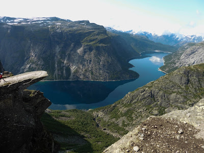
Then, after 5hrs of hiking, YOU'RE THERE!!!! Right in front of you is what you have undertaken this gruelling journey for, Trolltunga, or "troll's tongue" to give it its English translation. Was it worth it? Most certainly! It is everything you expected from all the photos you have seen of the landmark and certainly doesn't disappoint. But don't get too excited just yet. After this forced march what do you want to do? Yep, you want that very same photo you have seen time and time again on various social media posts; you, sat on the edge of a precipice with your feet dangling in thin air 700m above Ringedalsvatnet lake. Are you going to be able to just rock up and get that photo? If you hike up there in the busy season that is an emphatic NO.
 |
| What you normally see |
So, there you have it, a photo above of the deserted Trolltunga. What you DON'T see are the hordes of people desperate to have that exact same photo as you. And it's not only photos. We saw two marriage proposals (which had the whole area cheering and clapping the blissfully unaware couple) loads of propaganda type photos, which on this day included numerous groups of Ukrainians wanting to be photographed with their flag and anti Russian banners, and many other stunts too many to list. To actually arrive at the point you want to be when photographed you have to join a long, serpentine queue which snakes down, around and onto Trolltunga. You will see from our GPS track that the entire trip took us just over 11hrs. I am not exaggerating when I say a whole two hours of that was spent hanging around at the landmark queueing for our chance to be photographed. TWO HOURS!!!
The next consideration is WHO is going to take the photograph when you actually get to the tongue? Now, if you are in a group, you can stagger your position in the queue so that someone is always available to take photos, but that is going to take even longer. There are some industrious people who charge to take your camera from you and position themselves at a prime spot waiting to take a photograph of you. These can be identified by the fact they appear to be in possession of too many cameras. Obviously, this entails some risks like, are they going to take the photos on the right camera or are they even going to still be there when you get back? Then there are those kind souls who offer to hang around with your camera and take that golden photo out of the goodness of their own heart, but that entails the same risks as the prior option.
What did we do? Well, my son and daughter joined the queue straight away whilst I positioned myself at a suitable point to take the photo. When they arrived at the outcrop, my daughter ventured onto it and I took several photographs of her. When she was done, my son remained in the queue but allowed people to pass him whilst i made my way down to join him, passing my daughter on her way back up and handing over the camera. My son then resumed his place in the queue, with me, and was photographed by my daughter when his turn came. I quickly jumped on to get a few snaps with both of us in it before he made his way off and I was photographed alone by my daughter. Sadly, this meant we didn't get any photos with all three of us in them.
We took a few with all three of us in the photos from other locations though, just to prove we had been there together.


 There are plenty of opportunities on a warm day to strip off your boots and socks, as well as anything else you might want to strip off, and cool your feet, or other body parts, in cool, flowing streams and ponds. By far the least enjoyable part of the day was walking down the tarmac road to the finish. It's never ending, with one switch back after another. By this time it has been a looooong day, and you really just want to get to the end. You've been on the go for hours and, while walking down the road, you have two views which alternate over and over depending which side of the switch back you are walking


